


“A wonderful 100 miler that I would do again. Not many races of any distance will be more scenic”
– Joshua H.
YT 2012
“The course is beautiful and fast. I definitely enjoyed breathing the fresh air and seeing the multitude of stars at night. I think this would be a perfect course for someone who is doing their first 100 miler”
– Linda M.
YT 2012
The 100-mile and 100- mile Relay races start in West Yellowstone, Montana and the 50-mile race starts at mile 51 of the 100-mile course in the Lower Falls parking lot in Mesa Falls (outside of Ashton, ID).
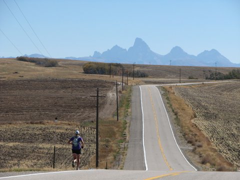
This is a road race that primarily follows the beautiful Scenic By-way from west entrance of Yellowstone National Park to the base of the Teton mountain range in Driggs, Idaho (just outside of Jackson Hole, Wyoming).
A detailed course description, with landmarks and Aid Station locations, can be downloaded HERE.
Click HERE to go to the maps page to see an overview of the course and an elevation profile.
 YELLOWSTONE-TETON ENDURANCE RUN – 100 MILER

ROUTE DESCRIPTION
Starting line for the YT 100 miler is in West Yellowstone, MT
Distance (mi) LANDMARK / TURN AID STATIONS
Start Bear Statue (on S. Canyon, south of Yellowstone Ave) START
0.25 Head south to dead end of S. Canyon and turn around
0.5 Return to Starting Line and pass by Bear Statue
0.57 Pass through intersection of Yellowstone Ave, continuing straight on Canyon
0.69 Turn RIGHT (west) onto Madison Ave
0.8 Turn Right (south) onto Boundary St
0.91 Turn RIGHT (west) onto Yellowstone Ave
1 Stay on Yellowstone Ave – passing through intersection of S/N Canyon
1.7 Turn RIGHT (north) onto Iris St.
2 Turn LEFT (west) onto Hwy 20/Targhee Pass Hwy
ALERT Course follows Hwy 20 for ~35 miles to the Mesa Falls Scenic Byway (Hwy 47), where it turns LEFT
6.2 South Fork Madison River Sign
7.5 KOA Campground Sign
9.1 Super 8 Motel/Lions Head
10.6 Idaho State Line / Welcome to Idaho Sign Water Only Stop
11.4 Howard Springs Rest Stop
13.2 Big Horn Hills
15.3 Valley View Laundry (after 1st Exxon Station) AID STATION #1
17.9 Meadow Creek Rd Sign
19.2 Flat Ranch Drift Lodge (left side)
21.4 2nd Exxon Station
22.7 Robins Roost
24.3 Stage Stop Gas (CONSTRUCTION ZONE – proceed with caution) AID STATION #2
27.7 Bank of Idaho / Phillips 66
28.1 Loop Road (left side)
29.8 Sinclair / Pond’s Lodge (CONSTRUCTION ZONE – use walking path on left side of bridge)
30.1 Island Park Ranger Station (left side) Water Only Stop
32.1 Chick Creek Road
33.5 Buffalo Run Campground & RV Park (left side)
34.2 Orvis Fly Shop / Shell Station (LAST GAS STATION BEFORE ASHTON)
37.3 TURN LEFT – MESA FALLS SCENIC BYWAY (Hwy #47)
ALERT DO NOT STAY ON HWY 20 – Sharp left turn onto Hwy 47
37.4 Proceed on Hwy #47 – Aid station in turn out/parking area on left AID STATION #3
39.1 Cattle Guard (first on scenic byway) – WATCH FOR COWS ON ROAD!!
39.85 Cattle Guard (number 2) – watch your step!
41.4 Forest Service Rd #315 (left side)
45.5 S. Hatchery Butte Rd (left side) Water Only Stop
46.4 Forest Service Rd #607 (right side)
48.6 Cattle Guard (third on scenic loop)
49.4 Pole Bridge Road sign (left side)
50.05 Mesa Falls – UPPER sign (50 MILE START) AID STATION #4
50.8 Mesa Falls – LOWER sign
52.8 Mesa Falls Scenic Byway Overlook (right side of road)
53.1 Large parking lot (right side of road) w/ restrooms; start section of narrow, widing road
ALERT Narrow, winding section of road with blind curves for 2.5 miles! Stop only in designated turn-outs
55.8 Leaving National Forest Sign (right side)
56.7 Warm River Bridge (start of steady uphill)
59.5 Cave Falls Road (left side)
60.5 COURSE TURN – Runners stay straight/slightly left onto 4000 E. AID STATION #5
ALERT DO NOT FOLLOW Hwy 47 as it curves to the right – stay straight!
60.6 Stay on 4000 E and cross over 1300 N – road drops downhill and to the right
61.7 4000 E dead ends at 1200 N
ALERT Turn LEFT onto 1200 N and cross Kirkham Bridge
61.8 Continue STRAIGHT on 1200 N until 4300 E
64.7 Turn RIGHT onto 4300 E (at Squirrel Cemetery and American Flag on flag pole)
ALERT Continue STRAIGHT on 4300 E, crossing 1100 N and 1000 N
66.7 When crossing 1000 N, DO NOT PARK near White House on left side of road…Owner is not friendly
67.5 Pavement turns to gravel
67.9 4300 E ends -> Turn right onto 875 N
69.7 Downhill & winding road – BE CAREFUL
70.6 Grainery Tower/shanty building
70.7 Turn LEFT onto Main Street (Children at Play & 15 Speed Limit Signs)
ALERT This is a tricky turn – look for the landmarks listed above, as well as an old white camper
70.8 Rough Riders Saloon (in Drummond, ID) AID STATION #6
70.9 Dead End at Stop Sign – Turn LEFT onto Hwy 32
74.5 Spring Hollow Road / Barricade (vertical pole) to close road in winter
78.1 4700 E
80.9 500 N AID STATION #7
81.9 Bridge
82.9 W. 14000 N
86.1 Entering Felt Sign
87 Badger Creek
89.8 Hwy 32 dead ends at Hwy 33
ALERT Turn Left (East) onto Hwy 33 (toward Driggs)
91.4 Town of Tetonia / North End Grille AID STATION #8
92.7 N. 2000 W / Cache Clawson Cemetery (Cross HWY and turn RIGHT)
ALERT RIGHT TURN from Hwy 33 onto N. 2000 W (gravel road) heading south
Follow N. 2000 W heading south – road is gravel
94.5 Cross W. 4000 N
95.5 Continue straight at W. 3000 N.
96 Road bends to the LEFT (EAST) at W 2500 N
97.5 Stop Sign on Hwy 33 (paved road)
ALERT Turn RIGHT onto Hwy 33 and cross to East Side of road – RUN FACING TRAFFIC
98.7 Kings Department Store (right side of road)
99.7 Tony’s Pizza & Pasta (right side of road)
100 Traffic signal in Driggs – proceed with caution when passing straight through intersection
100.05 FINISH – Front of Dreamchasers Store (47 South Main Street – Driggs) FINISH